The
only way to fully experience the Northern part of the
National Park, is by foot and the park is an ideal hiking
area. There
are marked trails alongside the edge of the canyon from Asbyrgi
up to the waterfall Selfoss. Many hikers venture even further, ending
at lake
Myvatn. Below is a short description of the main marked hiking
trails within the park:
Asbyrgi (Map no A-1) There are
several easy and interesting routes in the bottom of Asbyrgi starting
at the car park. Visitors can get a free
booklet containing a description of these routes from the park rangers.
Ashofdi circuit (Map no A-5) This route can
begin either at the shop, at the entrance to Asbyrgi or at the main
campsite. The whole circuit is 11 km and
takes about 3 hours. The path takes you first to Tofugja "The Fox Fissure" and up onto the edge of the
cliffs surrounding Asbyrgi. There is
a fixed rope to help you at this point. From there the trail heads east
to the Jokulsargljufur canyon and around the wooded
mull Ashofdi, from where there is a spectacular view.
Further east is a series of small gorges and ponds and to the west lies
the small lake Astjorn. A children's summer camp has been
operated here since 1946. If you start the hike at the shop the circuit
is 6 km long and only takes 1-2 hours. First you walk alongside Astjorn
and then follow the trail around the mull.
Eyjan
"The Island" in
Asbyrgi (Map no A-2) The trail upon
Eyjan or the “Island” in Asbyrgi
starts at the campsite and heads south. The view over Asbyrgi
and the sands to the north from the top is superb. The hike to the end
of Eyjan and back is 5 km and takes 1-2 hours.
Asbyrgi
– the rim of
Asbyrgi - Klappir - Jokulsa River – Asbyrgi (Map
no A-8) You can start
this walk either at the campsite in Asbyrgi or the
shop. It is easier, however, to get to the rim of the gorge by starting
from the shop as you avoid the rope-climb up Tofugja "The Fox Fissure".
The
trail takes you along the eastern rim of Asbyrgi as far south as
Klappir where the water has carved some amazing shapes into the rock.
The view over Asbyrgi is simply breathtaking. From Klappir you
head east over the moor to Jokulsa and then along the
canyon, passing Gilsbakki and As until you return to the
starting point. This route is 12 km long and takes 3-4 hours.
Hljodaklettar
( "The Sound
Cliffs" or "The Cliffs of Sounds" or "Echoing Rocks") circuit
(Map no
V-3) Hljodaklettar
(Echo rocks) are the remains of ancient
volcanoes which have been heavily eroded by the Jokulsa,
leaving only the volcanic plugs behind. The trail starts at the car
park at Hljodaklettar and it takes about 1 hour to walk the
2.4 km. Visitors can get a free booklet containing a description of
this trail from the park rangers.
Hljodaklettar
– Raudholar "Reddish hills" (Map no V-4) The trail
starts at the car park at Hljodaklettar and it
takes about 2 hours to walk the 5 km. The first part of the route
follows the main path, but by the cave Kirkjan (the Church) the trail
branches from the main path and rises along a gentle wooded slope
leading to Raudholar. During this fascinating walk you can
experience a great variety of geological phenomena and the views to the
canyon in the north and Hljodaklettar in the south are
exceptional.
Karl
og Kerling (Map
no V-5) Karl and
Kerling are two rock pillars, believed to be a pair of
petrified trolls, standing on a gravel bank by the river. It is a 30-40
minute stroll back and forth to them from the Hljodaklettar
car park.
Eyjan
in Vesturdalur (Map no V-1) From the
campsite in Vesturdalur a short trail leads around the
northernmost point of Eyjan, the “Island”, in
Vesturdalur.
Along the way you pass moss covered rocks and small pools. This easy
walk is ideal for an evening stroll.
Vesturdalur
- Svinadalur - Kallbjorg - Karl and Kerling – Vesturdalur
(Map no V-6) This route is 7
km long and takes 2-3 hours. It begins at the campsite
in Vesturdalur and follows the Vesturdalsa river south as far as
Einbui, a monolith at the head of the valley. On the way you
pass sedge-fringed ponds and there are numerous fascinating patterns in
the rocks. After passing by Einbui you ascend the southernmost
part of Eyjan (The Island) in Vesturdalur and continue to the site of
the
Svinadalur farm. From here the route continues east to
Kallbjorg cliffs by Jokulsa river. In the last century there was a
pulley over the river which was used to transport essentials from one
side to the other. Leaving Kallbjorg the path heads north past
the cavern Lambahellir (
The Lamb
Cave ) and the two rock trolls Karl
and Kerling. On the opposite
bank is the cavern Trollahellir (
The Trolls (Giants)
Cave ), the largest cave in the
canyon. The path
ends at the Hljodaklettar car park, from where it is a short
stroll to the campsite.
Holmatungur
circuit - Katlar (Map
no H-1) This 3.5 km
circuit around Holmatungur begins at the car park.
The route takes you north alongside the river Holma, with
its countless islets and angelica lined banks, all the way to the
Holmarfossar cascades. The return route heads south
alongside the Jokulsa to the confluence of the river
Melbugsa. This river falls off a ledge, forming the waterfall
Urridafoss, before meeting Jokulsa river. To get here you
have to take a short (0.5 km) diversion to look at Katlar, where the
Jokulsa channel narrows severely. The trail ends at the car
park. This walk, including the loop to Katlar, takes 1-2 hours. A short
distance from the car park is Mt. Ytra – Thorunnarfjall, with
a scenic view over Holmatungur
and Forvod.
Hafragil
lowland
(Hafragilsundirlendi) (Map no D-3) The area in and
surrounding Hafragil contains the most difficult hiking
trails in the National Park and caution should be exercised. You
approach this area from the south via Sanddalur where there is a fixed
rope to help you down a rocky section. Next you have to descend a steep
and rocky slope and then the walk continues past the majestic waterfall
Hafragilsfoss and through a rocky landslide along a small cove under a
vertical rock face. The route back up takes you into the Hafragil
gorge, following sheep tracks up the slope out of it. Visitors hiking
between Dettifoss and Holmatungur can bypass this area by
following the western edge of Hafragil instead. The circuit to the
Hafragil lowland starts at the car park by the turnoff to
Hafragilsfoss. It is 6 km long and takes about 3 hours.
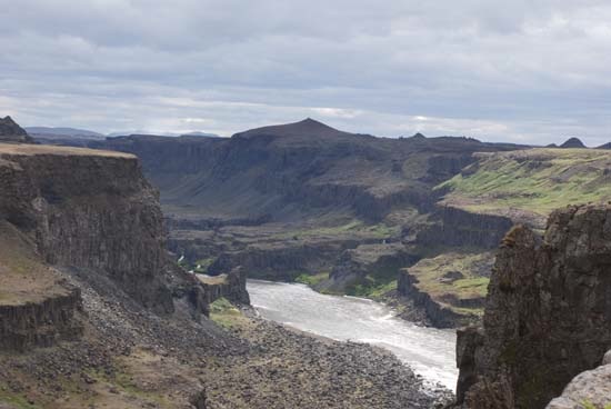
Dettifoss
– Selfoss (Map
no D-2) Dettifoss is
an approximately 15 minutes walk from the car park. From
Dettifoss there is a marked trail to Selfoss and from there back to the
car park. The circuit to Dettifoss and Selfoss is about 2.5 km and
takes 1 hour.
Asbyrgi
– Dettifoss (Map
no L-1, L-2 and L-3)The walk
from Asbyrgi to
Dettifoss takes about two days, with an
overnight stop at the campsite in Vesturdalur. There are two routes
from Asbyrgi to Vesturdalur. The first follows the edge of the Asbyrgi
gorge, via Klappir and Kviar, a total of 12 km.
The other route follows the Jokulsa river and is 13.6 km. From
Vesturdalur it is a further 8 km to Holmatungur and another 10
km to Dettifoss (11.5 km avoiding the area below Hafragil). With the
exception of Tofugja and Hafragil the route is generally
easy. North of Holmatungur you have to wade the spring fed
Stalla river. It is shallow and cold but an invigorating
experience and makes the trip even more memorable
|
 |
 |